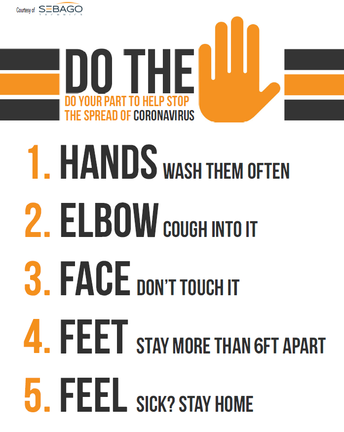
COVID-19 Safety Signs
In preparing for new Covid-19 safety measures and to remind our team members of best practices, Sebago Technics has put together a series of signs for our own office. In turn, we would like to support our communities and public agencies, by sharing them with you for your use in public buildings and facilities.
All of the signs linked below are free for you to download and print. We recommend laminating the signs so they last longer and can be easily cleaned. Feel free to share the signs with other communities. If you need support with printing and laminating, we’d be glad to help. Please contact Donna Larson, Community Planner.
Thank you for your efforts to create safe, proactive communities!
Story Maps
As consultants, we often take for granted our experience with a parcel of land. By the time planning staff and the community is engaged on a project, we have been studying the characteristics and information of the site for months. As we all now rely on virtual communication and meetings, we have developed a number of virtual solutions that can support a more informative and engaged public process during these times.
One of these solutions is Story Maps. What we really like about story maps is their ability to allow a “virtual walk” through a site at everyone’s own pace. Key data, site features and explanations of what is being observed can be added via audio and written text. This allows residents and officials to view at their own pace, and even go back if-needed. Base maps, videos, photos, drone footage can all be shown in their actual location through geo-referencing. Each story map is developed to highlight and explain key features, aspects or concerns with the subject property. Everyone sees the same information from their home, office or anywhere they access the internet.
We believe that long after the need to collaborate virtually has passed, story maps will be a foundational component of the engagement process. This easy-to-use tool will allow community planners and residents to engage in a more consistent and comprehensive way than has typically been available. The goal and result are to create a better understanding, more meaningful dialogue and a more successful process.
Example of a Guided Media Tour
For more information on Story Maps, contact Donna Larson, AICP, Community Planner.
Drone Photography
Whether you’re studying traffic patterns, view tracts of land that might be remote or difficult to reach on foot, plan for infrastructure improvements, inspect a tall structure or survey roads or large open areas, Unmanned Aerial Vehicles (UAVs), also known as Drones, are a new tool for the job.
UAVs can be used in many ways. Sebago’s UAVs Drones can take high definition videos, panoramas and/or still photos. They are also able to survey land, roads, structures and buildings to create 3-dimensional images and models.
As we look for ways to inform and engage communities in land planning issues, UAVs provide a unique perspective and an informative tool. And, they can easily be incorporated into a virtual meeting. In a cost-effective and responsive manner.
If you’d like more information about Sebago’s UAV and Geomatics Services please contact Donna Larson, AICP, Community Planner.