In the fast-paced world of civil engineering, efficient project management is paramount. The process of due diligence, in particular, plays a crucial role in assessing project feasibility and potential challenges. By harnessing the power of public datasets, civil engineering firms can significantly expedite this process and arm their project managers with valuable insights. In this blog post, we’ll delve into how finding and using public datasets can enhance project efficiency and contribute to better-informed decision-making.
The Significance of Due Diligence
Before embarking on any construction project, thorough due diligence is essential. This phase involves gathering comprehensive information about the project site to understand its constraints, potential, and any existing limitations. Traditionally, due diligence could be a time-consuming process, involving multiple data collection methods and visits to various municipal offices. However, in the digital age, public datasets have revolutionized this process.
The Power of Public Datasets
Public datasets, often made available by government agencies and other organizations, provide a treasure trove of information that can aid in site analysis. By tapping into these resources, civil engineering firms can gain valuable insights quickly, enabling them to make more informed decisions right from the start.
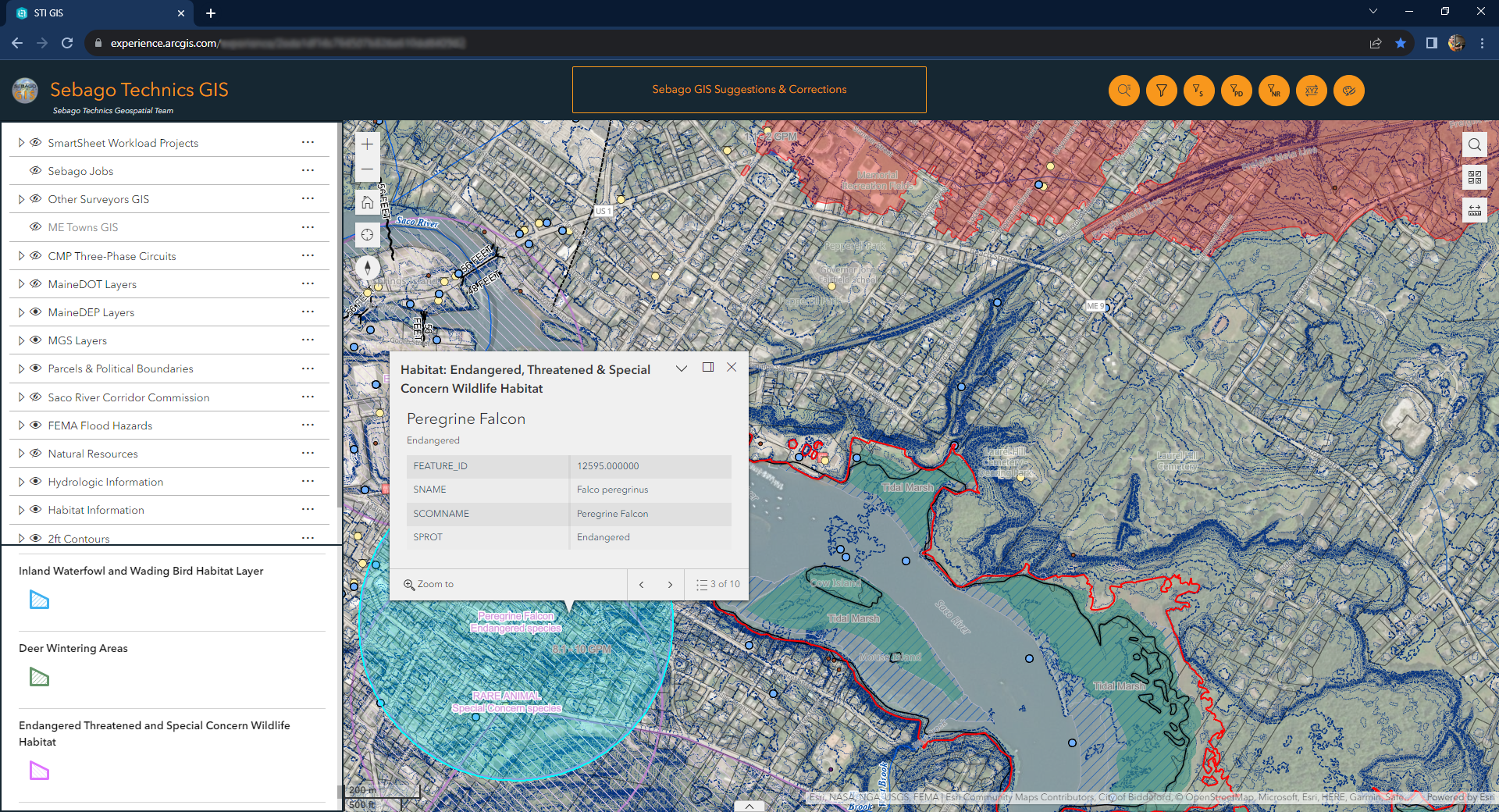
Key Public Datasets for Site Analysis
- Parcel Boundary Data: Understanding the boundaries of the project site is essential. Public datasets often provide accurate parcel maps, informing the plan of action and providing clients important insights about the feasibility of their project.
- Topographical Information: Digital elevation models and contour maps derived from public datasets offer insights into the site’s terrain, and can be used to supplement on-the-ground survey topographical information – saving valuable time in the field. This information is crucial for designing foundations, drainage systems, and roadways.
- Essential Habitat Data: Public datasets might include information about ecologically sensitive areas and protected habitats. This knowledge helps engineering firms navigate environmental regulations more effectively.
- Hydrology/Hydrography Data: Understanding water flow patterns, flood zones, wetlands, and nearby bodies of water is critical. Public hydrology and hydrography datasets contribute to smarter water management strategies and help to map natural resource setbacks, allowing Project Managers a greater understanding of the useable area on a site.
- Soil Composition Data: Soil composition and permeability have a significant impact on stormwater management and septic design. Public soil datasets provide quick access to this vital information.
- Municipal Zoning Data: Public zoning datasets outline the permissible land uses and restrictions in the area. This information guides project managers in compliance with local regulations.
Streamlining Decision-Making and Strategy
By accessing these datasets early in the project lifecycle, Project Managers can expedite the due diligence process. Instead of spending valuable time collecting data, they can focus on analyzing the information and devising effective strategies. Swift access to encumbrance details empowers project managers to make informed decisions about project viability, scope, and potential challenges.
The Role of Technology
Advanced data analysis tools and Geographic Information Systems (GIS) play a vital role in translating raw data from public datasets into actionable insights. These tools enable civil engineers to create visual representations of the site, overlay different datasets, and identify correlations that might impact project planning.
Conclusion
In the realm of civil engineering, time is money. The judicious use of public datasets can significantly accelerate the due diligence process, providing project managers with crucial information about the project site’s boundaries, topography, habitats, hydrology, soils, and zoning regulations. Armed with this knowledge, engineering firms can formulate efficient strategies and approximate estimates, ultimately leading to smoother project execution and increased overall efficiency. Embracing the power of public datasets is more than a technological advancement; it’s a smart business move that can elevate the success of civil engineering projects in today’s dynamic landscape.
At Sebago Technics, we understand the importance of efficiency in every phase of a project. With our cutting-edge technological tools and expertise, we stand ready to lead the way in utilizing public datasets to enhance your project’s due diligence process. Our skilled team of civil engineers and data analysts are well-versed in transforming raw data into actionable insights that drive informed decision-making. By leveraging our proficiency in GIS and advanced data analysis techniques, we can streamline your project’s initiation while ensuring compliance with regulations and optimizing strategies. At Sebago Technics, we’re not just a civil engineering firm; we’re your strategic partner in achieving success through innovation and efficiency. Contact us today to learn how we can empower your projects through the smart utilization of public datasets.