In the realm of civil engineering, efficiency and accuracy are paramount. The traditional methods of data collection in the field often involve tedious note-taking, disconnected photographs, and cumbersome paperwork back at the office. However, with the advent of Geographic Information Systems (GIS) technology, a transformative shift is underway. In this blog post, we’ll delve into how utilizing GIS applications for mobile data collection not only simplifies the fieldwork process but also paves the way for automatic report generation, ultimately saving time, resources, and enhancing data quality.
Empowering Non-GIS Professionals
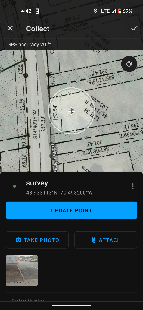
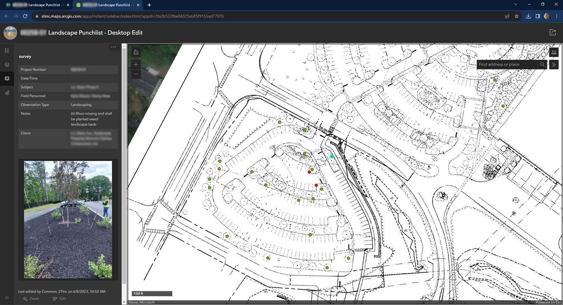
The barrier to entry for GIS technology has significantly lowered with the introduction of mobile ArcGIS Online applications. These user-friendly tools extend their benefits beyond GIS and survey professionals, enabling everyone in the field to gather and edit geographic data effortlessly. The intuitive interfaces make it easy for engineers and other non-GIS specialists to record data accurately and efficiently.
Comprehensive Data Collection
Beyond mere geographic coordinates, these mobile applications empower field professionals to capture a wealth of information about each feature they collect. This multifaceted data includes:
Pictures: Visual documentation provides context and aids in better decision-making during analysis.
Notes: Annotating features with notes ensures that critical details and observations are recorded in real-time.
Date/Time Stamps: Precise time tracking enables accurate chronological sequencing of events.
Submitting Users: Identifying who collected the data contributes to accountability and transparency.
Relevant Information: Tailoring data collection forms to include information specific to the features being documented enhances the dataset’s richness.
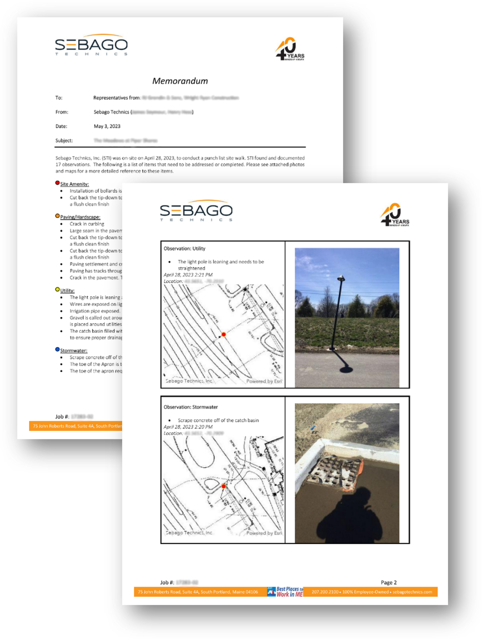
Streamlined Report Generation
One of the most significant advantages of utilizing GIS technology in the field is its seamless integration with the reporting process. Traditional reporting often involves hours of sifting through disconnected photographs, deciphering handwritten notes, and manually compiling information. With GIS, the collected data is directly tied to the geographic features, creating a unified digital dataset.
By leveraging this rich dataset, automatic report generation becomes a reality. The previously time-consuming task of interpreting and organizing field data is replaced by streamlined, automated processes. This not only saves countless hours of office work but also reduces errors and discrepancies that can arise from disconnected information.
Enhanced Data Quality and Efficiency
Collecting data through mobile ArcGIS Online applications improves the overall quality of the dataset. The real-time nature of data entry minimizes the chances of missing or misinterpreting critical information. This, in turn, leads to more accurate analysis, decision-making, and project outcomes.
The seamless transition from data collection to automatic report generation ensures that insights are quickly transformed into actionable information.
Conclusion
Incorporating GIS technology into field data collection represents a paradigm shift in the world of civil engineering. The suite of mobile ArcGIS Online applications empowers non-GIS professionals to gather comprehensive geographic data effortlessly. From photographs to notes, time stamps, and submitting users, every piece of information contributes to a holistic dataset. The integration of GIS technology with automatic report generation saves time, enhances data quality, and facilitates better decision-making.
At Sebago Technics, we’re committed to pushing the boundaries of innovation in civil engineering. Our expertise in utilizing GIS technology for mobile data collection and automatic report generation sets us apart as industry leaders. We understand that efficiency, accuracy, and seamless integration are the cornerstones of successful projects. With our team’s proficiency in harnessing the power of GIS applications, we empower both field professionals and decision-makers to make informed choices based on accurate and comprehensive data. Contact us today to elevate your projects through the power of GIS.